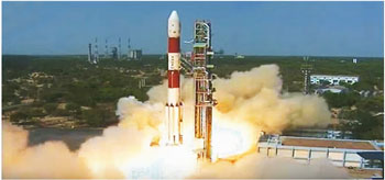
New Delhi: India’s Polar Satellite Launch Vehicle (PSLV) in its 40th flight on Friday successfully launched 31 satellites in one go into a 505 km polar Sun-Synchronous orbit.
The ISRO- made rocket PSLV C-38, carried a 712- kg Cartosat- 2 series Earth- observing satellite and 30 co-passenger satellites together weighing 243kg.
The co-passenger satellites comprise 29 nano satellites from 14 countries and one from India that is developed by college students of Noorul Islam University in Kanyakumari district.
Other 29 International Nano satellites were launched as part of the commercial arrangements between Antrix Corporation Limited (Antrix), a Government of India company under Department of Space (DOS) and the commercial arm of ISRO and the International customers.
Taking another step forward in the space technology, the rocket took off from the first launch pad at Satish Dhawan Space Centre (SDSC) at 9.29 am on Friday from the spaceport of Sriharikota, about 100 km from the north off Chennai.
Soon after the mission was declared a success, ISRO chairman A S Kiran Kumar congratulated the entire ISRO team saying, “It comes just 18 days after the fruitful maiden test flight of the 4-ton class launch vehicle GSLV Mark-III.”
“Today’s success of the PSLV mission reinforces the trust of global space technology users on the highly versatile launch vehicle PSLV. The Cartosat-2 series satellite is set to be an agile ‘eye in the sky’ for India to devise development plans,” kumar added.
On the other side, President Pranab Mukherjee also congratulates ISRO on successful launch, he tweeted from Rashtrapati bhawan that, “Congratulations to ISRO team on the successful launch of PSLV-C38 carrying 31 satellites.”
Prime Minister Narendra Modi as well applauded for ISRO on its successful launch. He said, “Congratulations to ISRO on its 40th successful Polar satellite launch carrying 31 satellites from 15 countries. You make us proud!”
The primary Cartosat-2 series satellite, carried by PSLV C-38 is a remote sensing satellite, after its injection into the required orbit; the satellite will be brought to operational configuration following which it will begin providing regular remote sensing services using its panchromatic and multispectral cameras.
The imagery sent by the satellite will be useful for cartographic applications, urban and rural applications, coastal land use and regulation, utility management like road network monitoring, water distribution, creation of land use maps, change detection to bring out geographical and man-made features and various other land information system as well as geographical information system (GIS) applications.
Ends